Upper Missouri River Breaks National Monument : Interesting Facts, History & Travel Guide

- By
- Aparna Patel
- |
- 13 Apr, 2023
- |
Upper Missouri River Breaks National Monument is a rugged and scenic destination located in central Montana. This vast and remote wilderness is home to some of the most spectacular and unspoiled landscapes in the country, including towering sandstone cliffs, deep canyons, and winding river channels.
In this article, we will explore the interesting facts, rich history, and travel guide to help you plan your visit to Upper Missouri River Breaks National Monument. Whether you’re an outdoor enthusiast, history buff, or simply seeking a peaceful retreat into nature, this monument has something for everyone to enjoy. So, let’s dive in and discover all that Upper Missouri River Breaks has to offer!
Table of Contents
Interesting facts about Upper Missouri River Breaks National Monument
- Upper Missouri River Breaks National Monument is located in the state of Montana, USA, and covers over 375,000 acres of land along the Missouri River.
- The area is known for its rugged terrain, towering cliffs, and pristine wilderness, and is home to a variety of wildlife, including bighorn sheep, elk, and bald eagles.
- The monument was established in 2001 by President Bill Clinton under the Antiquities Act, which allows the president to protect and preserve important cultural and natural resources.
- The monument contains numerous cultural and historic sites, including Native American rock art, homesteads, and historic forts and battlefields.
- The Missouri River, which flows through the monument, was an important transportation route for Native Americans, explorers, fur traders, and settlers.
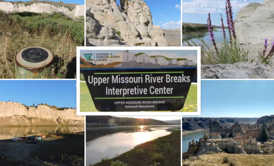
- The monument is also home to the Upper Missouri River Breaks National Monument Interpretive Center, which provides information and exhibits on the area’s natural and cultural history.
- Visitors to the monument can enjoy a variety of recreational activities, including hiking, camping, fishing, and boating. The monument also offers guided river trips, birdwatching tours, and stargazing programs.
Related Articles
- Vermilion Cliffs National Monument : Interesting Facts, History & Travel Guide
- Waco Mammoth National Monument : Interesting Facts, History & Travel Guide
- Walnut Canyon National Monument : Interesting Facts, History
- Wupatki National Monument : Interesting Facts, History & Travel Guide
- Yucca House National Monument : Interesting Facts, History
- Sonoran Desert National Monument : Interesting Facts, History & Travel Guide
Information & History of Upper Missouri River Breaks National Monument
Upper Missouri River Breaks National Monument is a protected area located in north-central Montana, United States. The monument covers over 375,000 acres of land along the Missouri River and was established in 2001 by President Bill Clinton under the authority of the Antiquities Act. Here is some information and history about Upper Missouri River Breaks National Monument:
Geography and Geology:
The monument is situated along the Missouri River, which is the longest river in North America. The Missouri River in the Upper Missouri River Breaks area is characterized by steep, towering sandstone cliffs that form deep canyons and breaks, creating a rugged and remote landscape. The area is also home to a variety of plant and animal species, including bighorn sheep, elk, pronghorn antelope, and bald eagles.
Native American History:
The Upper Missouri River Breaks area has a rich history of Native American occupation and use. Archaeological evidence suggests that the area has been inhabited for at least 10,000 years, and various tribes, including the A’aninin (Gros Ventre), Assiniboine, Blackfeet, and Sioux, used the area for hunting, fishing, and trade. The area is also home to numerous Native American rock art sites, including petroglyphs and pictographs, which provide a glimpse into the spiritual and cultural lives of the people who lived in the area.
European Exploration and Settlement:
In the early 1800s, the area was explored by Meriwether Lewis and William Clark during their expedition to the Pacific Northwest. The Missouri River was an important transportation route for explorers, fur traders, and settlers, and several forts were established in the area to protect and trade with Native American tribes. Homesteaders also settled in the area and established ranches and farms.
Conservation and Protection:
The Upper Missouri River Breaks area has been the subject of conservation efforts for decades, and in 1968, the Wild and Scenic Rivers Act designated a 149-mile section of the Missouri River in the area as a National Wild and Scenic River. In 2001, President Bill Clinton designated the area as a National Monument, ensuring its protection for future generations. Today, the monument is managed by the Bureau of Land Management and provides opportunities for recreation, education, and cultural exploration.
Why is it called the Missouri Breaks?
The Missouri Breaks is a region of central Montana in the United States that is named after the Missouri River, which flows through the area. The term “breaks” refers to the eroded, rugged terrain of the region, which was created by the river’s meandering and cutting through layers of rock over millions of years.
The Missouri Breaks region was an important area for Native American tribes, including the Sioux, Cheyenne, and Crow, who used the area for hunting and fishing. It also played a significant role in the history of the American West, particularly during the 19th century, when it was a center of fur trapping, gold mining, and cattle ranching.
The name “Missouri Breaks” was likely first used by early fur trappers and traders who traveled through the region, and it has since become a widely recognized term for this distinctive landscape. The Missouri Breaks National Monument, established in 2001, preserves much of the area’s natural and cultural resources for future generations.
Upper Missouri River Breaks National Monument camping
The Upper Missouri River Breaks National Monument is a beautiful area in central Montana that offers a range of outdoor recreational activities, including camping, hiking, fishing, and boating. There are several options for camping within the monument, depending on your preferences and needs.
There are two main campgrounds within the national monument: the James Kipp Recreation Area and the Bureau of Land Management (BLM) campground. Both of these campgrounds offer basic amenities such as restrooms, picnic tables, and fire rings, but they do not have water or electric hookups. These sites are available on a first-come, first-served basis, so it’s a good idea to arrive early to secure a spot.
In addition to these campgrounds, there are also several primitive camping options available within the monument. These sites are dispersed throughout the area and do not have any amenities, so you will need to bring your own water and be prepared to pack out all of your trash.
It’s important to note that the Upper Missouri River Breaks National Monument has limited facilities, so visitors should plan to bring all necessary camping gear, food, and water. Additionally, campfires may be restricted during times of high fire danger, so be sure to check with local authorities for any fire restrictions in the area.
Overall, camping in the Upper Missouri River Breaks National Monument can be a rewarding and memorable experience for those who enjoy the great outdoors.
Travel Guide for Upper Missouri River Breaks National Monument
Best Time to Visit:
The best time to visit Upper Missouri River Breaks National Monument is from May to September when the weather is mild and most recreational activities are available.
How to Get There:
The nearest major airport to the monument is Great Falls International Airport, which is about 70 miles away. From there, you can rent a car and drive to the monument.
Things to Do:
- Take a scenic drive along the Missouri River Breaks Backcountry Byway, which offers stunning views of the rugged landscape.
- Go on a guided river trip or rent a canoe or kayak to explore the Missouri River.
- Hike one of the many trails in the monument, such as the Hole in the Wall Trail, which leads to a natural sandstone arch.
- Visit the Upper Missouri River Breaks National Monument Interpretive Center in Fort Benton, which offers exhibits and information about the area’s natural and cultural history.
- Go fishing in the Missouri River, which is home to several species of fish, including trout and walleye.
- Camp at one of the developed campgrounds or primitive campsites in the monument.
Where to Stay:
The monument offers several developed campgrounds and primitive campsites for visitors who want to camp. There are also several lodging options in nearby towns, such as Fort Benton, Loma, and Winifred.
Tips:
- The monument is remote and rugged, so be sure to bring plenty of water, food, and supplies.
- Be aware of the weather, as the area can experience sudden thunderstorms and flash floods.
- Respect the natural and cultural resources of the monument and leave no trace of your visit.
Check the Bureau of Land Management website for updates on road closures and other important information.
Search Posts
Latest posts
-
5 Mar, 2024
Why prohibit engine braking?
-
4 Mar, 2024
Why would you wrap your luggage in plastic?
-
4 Mar, 2024
Why are there no seat belts on trains?
-
4 Mar, 2024
Can I accidentally miss the in-flight food?
Popular posts
-
5 Mar, 2024
Why prohibit engine braking?